|
 Introduction
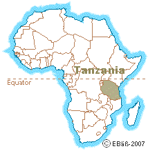 Situated in
East Africa, just south of the equator, mainland Tanzania lies
between the area of the great lakes; Victoria, Tanganyika and Malawi
- with the Indian Ocean on its' coastline to the east. It has land
borders with Uganda and Kenya to the north, Mozambique and Malawi to
the south, Zambia to the southwest and Zaire, Burundi and Rwanda to
the west. Situated in
East Africa, just south of the equator, mainland Tanzania lies
between the area of the great lakes; Victoria, Tanganyika and Malawi
- with the Indian Ocean on its' coastline to the east. It has land
borders with Uganda and Kenya to the north, Mozambique and Malawi to
the south, Zambia to the southwest and Zaire, Burundi and Rwanda to
the west.
The country lies at an altitude of over 1,000ft, apart from a
coastal strip varying in width from 10 to 40 miles. The greater part
of the country is made up of plateau averaging 3,000 to 4,500ft in
height. Mountains are grouped in various section. The Pare and
Usambara ranges are in the northeast and the Livingstone Mountains
in the southwest. Kilimanjaro (19,340ft) in the north is the highest
mountain in Africa.
On the borders are three large lakes; Victoria, the second-largest
freshwater lake in the world, Tanganyika, second only to Lake Baykal
as the deepest in the world; and Lake Malawi. Lakes within Tanzania
include Natron, Eyasi, Manyara and Rukwa.
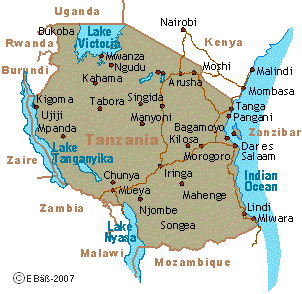 Even though three great African rivers; the Nile, the Zaire and the
Zambezi, have their origins in Tanzania, the country has few
permanent rivers. During half the year, the central plateau has no
running water, but in the rainy season flooding presents a problem. Even though three great African rivers; the Nile, the Zaire and the
Zambezi, have their origins in Tanzania, the country has few
permanent rivers. During half the year, the central plateau has no
running water, but in the rainy season flooding presents a problem.
Lowest Point: Indian Ocean 0m
Highest Point: Kilimanjaro 5,895m
origin: africaguide.com |
Facts:
Full name:
United Republic of Tanzania
Population:
38.4 million (UN, 2005)
Capital:
Dodoma (official), Dar es Salaam (commercial)
Largest city:
Dar es Salaam
Area: 945,087 sq km
(364,900 sq miles)
Major languages: English, Swahili
Major religions:
Christianity, Islam
Life expectancy: 46 years (men), 46
years (women) (UN)
Monetary unit:
1 Tanzanian shilling = 100 cents
Main exports: Sisal, cloves, coffee,
cotton, cashew nuts, minerals, tobacco
GNI per capita: US $340 (World Bank,
2006)
Internet domain: .tz
International dialling code: +255
origin: BBC-News |